Techniques:
Finding out about the lives of marine mammals by tagging them with temporary electronic devices is not a new idea - as long ago as 1940 the Norwegian Per Scholander reported developing mechanical oceanographic depth gauges to record the diving depths of whales. Scholander himself explained how he got the idea from a description written by Lord Kelvin in the 19th Century.
Early instruments were bulky, and, like many current devices, were 'data loggers' which have to be recovered in order to retrieve the measurements which they have recorded. Data loggers can be lost, and when data is recovered, it is only available some time after the measurements were made. An alternative, which is possible today, is to add transmitters to measuring devices. This means that results are received, almost in real-time, even if a device is ultimately lost.
However, even in an era of ever increasing electronic miniaturization, and global communication systems, it might come as a surprise to realise that, to put it plainly, it’s not so easy to make this work.
There is a satellite communication system, called ARGOS, which gives researchers the opportunity to ‘beam’ data from remote locations. However, in its present form the ARGOS satellite provides only limited data transfer. This means that only quite small packets of data may be sent each day, only when the ARGOS satellite is over the remote location, and, critically, data may only be sent from the transmitter to the satellite. The last restriction means that a tag transmitting data cannot 'know' that its message has been received.
Add to these restrictions the limitations that a tag must survive extremes of pressure, cold, exposure to salt water, and physical shock, perhaps for many months, with limited power, and no maintenance or support. It becomes apparent that collecting data from a tag in this way is, in certain respects, as difficult a technical problem as managing remote systems on a probe used for space exploration. In some ways it is actually even more challenging.
| Visualization |
- Data obtained from SEaOS was visualized using software called MAMVIS.
- MAMVIS is a system first developed by researchers based at SMRU in the mid 1990s. Since then MAMVIS, software developed specifically to assist in visualizating data collected from studies of marine mammals, has been constantly updated and improved.
- The program allows biologists to explore complex datasets in a number of ways. MAMVIS can overlay data logged from tags on to three dimensional maps of the ocean, and allow researchers to create and animate graphics which replay behaviours.
- Examples of MAMVIS output:
|
|
What is a tag?
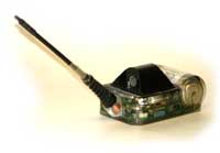
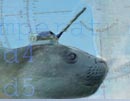
 The tags used by SEaOS are small computers designed and built by SMRU with sensors which allow them to make several measurements about their immediate environment. They have memory in which they store data, a transmitter, a clock, and batteries, all moulded securely into a resin block. Tags are fixed harmlessly to seals' fur, typically for periods of several months. The tags are not buoyant, and are lost when they drop off. The tags used by SEaOS are small computers designed and built by SMRU with sensors which allow them to make several measurements about their immediate environment. They have memory in which they store data, a transmitter, a clock, and batteries, all moulded securely into a resin block. Tags are fixed harmlessly to seals' fur, typically for periods of several months. The tags are not buoyant, and are lost when they drop off.
|
 What does a tag do? What does a tag do?
Our tags do five key things:
- Take measurements of key environmental parameters: Time of measurement, status (wet or dry), water conductivity, water temperature, depth.
- Analyse measurements to create profiles of seal behaviour, and ocean temperature and salinity changes with depth. These profiles are used to decide what information to store in the tag's journal.
- Store journal data until transmission opportunities occur.
- Transmit stored data to the ARGOS satellite.
- Monitor and manage the tag's own limted resources of power and memory.
These measurements are stored and transmitted to the ARGOS satellite.

|
Movie:
Relaying Data from Tags
|
|
 What’s clever about our tags? What’s clever about our tags?
The short answer is, the software. The program in the tag’s computer has to work independent of any help or support from the moment the tag wakes up on a seal, to months later when it ends its data gathering mission. It must manage limited battery power, decide when circumstances have changed and new measurements must be made, and detect potential data transmission windows (tags can only transmit at the surface).
The tag must also create digests from actual measurements to reduce the amount of information which must be transmitted. This is a process which requires the program to do more than simply compress data – it must also study information gathered to determine which parts are likely to be of interest. In addition the program must try to send representative data packets without confirmation that they have been received. In practice this requires a disciplined ‘data publication’ routine to optimise the probability that as much  as possible of the tag’s precious journal will be received. as possible of the tag’s precious journal will be received.
All this is a tall order. The program used in tags is constantly being redeveloped to accommodate new technical advances, and new data requirements. The current version of the tag control software is over 20,000 lines of code long. In the future it is hoped to develop systems which can be dynamically updated during data collection missions, however these enhancements will require new satellites allowing scientists to establish two-way communication. |
|


![]()


 What does a tag do?
 What’s clever about our tags?
 as possible of the tag’s precious journal will be received.